บทความ

08.06.2561 Lawka Nanda Pagoda : เจดีย์ Lawka Nanda ริมฝั่งแม่น้ำอิรวดี แขวงพะสิม ภูมิภาคอิรวดี สาธารณรัฐแห่งสหภาพเมียนมา.

รูปภาพ
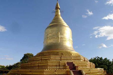
1. ขอบคุณ ภาพและข้อมูล จาก https://www.gomyanmartours.com/lawka-nanda-pagoda/ Lawka Nanda Pagoda     Estimated 11th century Merit of King Anawrahta (r. 1044-1077) The 86 ft-high pagoda lies on a hill on the bank of the Ayeyarwaddy River. Foreign ships once moored here in ancient times. The lower reaches of the river and the delta did not seem to be as silted up as now and it is believed that sea-faring vessels could sail up to this port.  01.  Lawka Nanda Pagoda Stupa Old chronicles state that a hair relic of the Buddha was enshrined here. The oldest Buddha footprint in stone was discovered there, now on display at the Bagan Archaeological Museum. One of the two stone inscriptions dated 1207, mentions a monastery built by King Anawrahta, and gives the name of this pagoda. 02.  Lawka Nanda Pagoda 2. แปลโดย Google แปลภาษา เจดีย์ Lawka Nanda   ประมาณศตวรรษที่ 11 บุญของกษัตริย์ Anawrahta (r. 1044-1077) เจดีย์สูง 86 ฟุตตั้งอยู่บนเนินเขาที่อยู่ริมฝั่งแม่น้ำ A

08.06.2561 Pathein Suspension Bridge, Myanmar December 2017 : สะพานแขวนพะสิม แขวงพะสิม ภูมิภาคอิรวดี สาธารณรัฐแห่งสหภาพเมียนมา.

รูปภาพ
1. ขอบคุณ สำหรับภาพและข้อมูล สะพานแขวนพะสิม แขวงพะสิม ภูมิภาคอิรวดี สาธารณรัฐแห่งสหภาพเมียนมา. Pathein Suspension Bridge, Myanmar December 2017 สะพานแขวนพะสิม แขวงพะสิม ภูมิภาคอิรวดี สาธารณรัฐแห่งสหภาพเมียนมา. 2.  Pathein Bridge : สะพาน(แขวน)พะสิม แขวง(อำเภอ)พะสิม ภูมิภาคอิรวดี สาธารณรัฐแห่งสหภาพเมียนมา. Pathein Bridge is 2,140 feet long and it is of reinforced concrete and steel frame suspension bridge and eighty per cent of the whole task has so far been built. It's easy and smooth transportation can be achieved for the relations between the regions of Ngwehsaung Beach and Chaungtha Beach in all seasons. สะพาน Pathein มีความยาว 2,140 ฟุตและเป็นโครงเหล็กเสริมคอนกรีตและโครงเหล็กแขวนและร้อยละแปดสิบของงานทั้งหมดได้รับการสร้างขึ้นมาแล้ว การคมนาคมขนส่งที่เรียบง่ายและราบรื่นสามารถทำได้สำหรับความสัมพันธ์ระหว่างพื้นที่ของหาด Ngwehsaung และหาดเชิงทะเลในทุกฤดูกาล

08.06.2561 River View Point : จุดชมทิวทัศน์ของแม่น้ำ แขวง(อำเภอ)พะสิม ภูมิภาคอิรวดี สาธารณรัฐแห่งสหภาพเมียนมา.

รูปภาพ
1. ขอบคุณ ภาพและข้อมูล จาก https://www.mmtimes.com/news/river-view-point.html#.Wxpl-PlHQZA.facebook ZUZAKAR KALAUNG   01 JUN 2018  01.  Chicken Cashew at River View Point. Zuzakar Kalaung/The Myanmar Times ไก่มะม่วงหิมพานต์ที่จุดชมแม่น้ำ.  Zuzakar Kalaung / The Myanmar Times Not a great pot but a good spot.  Long distancesjourneys in bus are a pain. Roads are bumpy. Seats are uncomfortable. Oddly, this is one area where technology can make things worse. Over air-conditioned buses become fridges on wheels. Screens blast budget movies nobody really wants to watch (look around you, nobody watches them, really).   Solace only comes when the bus pulls out for a quick break in a restaurant on the side of the road.  In this regard, the chain “Feel” is a traveler’s reward.   But you might get bored of it after a while. Thankfully, sometimes, a daring driver improvises and takes you to a hidden place.   02.  Watercress salad. Zuzakar Kalaung/The My

01.06.2561 Pathein District is a district of Ayeyawady Region (Division), Myanmar.

รูปภาพ
01.  Pathein District    is a  district  of  Ayeyawady Region (Division ) ,  Myanmar . Pathein District From Wikipedia, the free encyclopedia Jump to navigation Jump to search Pathein District ပုသိမ်ခရိုင် District of  Ayeyarwady Division Pathein District Coordinates:  16°45′0″N   94°30′0″E Coordinates :  16°45′0″N   94°30′0″E Country Myanmar Division Ayeyarwady District Pathein Area  • Total 28,230 km 2  (10,899.8 sq mi) Population  (2014)  • Total 1,630,716 Time zone MST  ( UTC6:30 ) Pathein District  ( Burmese :  ပုသိမ်ခရိုင် ) is a  district  of  Ayeyawady Division ,  Myanmar . It is located around the city of  Pathein  and includes the urban area of it. The area of the Pathein District is 10899.8 km². Its population was 1,630,716 in 2014. [1] Map of Pathein District Townships [ edit ] The district consists of the following  townships : Pathein Township Kangyidaunk Township Thabaung Township Kyonpyaw Township Yekyi Townsh

01.06.2561 แขวง (อำเภอ) พะสิม หรือ บัสเซียน (Bassein) ภูมิภาค (เขต) อิรวดี สาธารณรัฐแห่งสหภาพเมียนมา.

รูปภาพ
01. แขวง (อำเภอ) พะสิม หรือ  บัสเซียน  ( Bassein ) ภูมิภาค (เขต) อิรวดี สาธารณรัฐแห่งสหภาพเมียนมา. พะสิม จากวิกิพีเดีย สารานุกรมเสรี พะสิม ပုသိမ်မြို့ บัสเซียน พะสิม ที่ตั้งของเมืองพะสิม ใน ประเทศพม่า พิกัดภูมิศาสตร์:  16°46′0″N   94°43′0″E ประเทศ   พม่า เขต เขตอิรวดี อำเภอ อำเภอพะสิม ตำบล ตำบลพะสิม ประชากร  • ทั้งหมด 237,089 (2,017)  • ชาติพันธุ์ ชาวพม่า ,  พม่าเชื้อสายอินเดีย ,  ชาวกะเหรี่ยง  • ศาสนา ศาสนาพุทธ เขตเวลา MST  ( UTC+6.30 ) รหัสพื้นที่ 42 [1] พะสิม  ( พม่า :  ပုသိမ်မြို့ ;  MLCTS :  pu. sim mrui. ,  เสียงอ่านภาษาพม่า:  [pəθèiɴ mjo̰] ;  มอญ :  ဖာသဳ   พะแซม ) หรือ  บัสเซียน  ( อังกฤษ :  Bassein ) เป็นเมืองท่าสำคัญและเป็นเมืองศูนย์กลางของ เขตอิรวดี  ห่างจากนคร ย่างกุ้ง มาทางตะวันตกเฉียงใต้ 190 กิโลเมตร (120 ไมล์) ริม แม่น้ำพะสิม  ซึ่งเป็นแม่น้ำสาขาฝั่งตะวันตกของ แม่น้ำอิรวดี [2]  เมืองนี้มีประชากร 237,089 คน (ค.ศ. 2017) ถึงแม้จะเคยเป็นส่วนหนึ่งของ อาณาจักรมอญ  แต่ปัจจุบันก็มี ชาวมอญ เหลืออยู่น้อยมาก กลุ่มชาติพันธุ์หลักในปัจจุบัน